2026-07-25 18:01:48
In today’s dispatch:
Greening the Sahara
German Environmentalists Worsen the Environment
Wisconsin’s Bald Eagle Nests
Record Fires
The US Nuclear Renaissance
Deaths from Heatwaves in Europe
Meanwhile in China
Energy Transitions Are Getting More Efficient
Solar Prices
Efficient Solar Installation
Solar Everywhere
Does Solar Degrade Fast?
Batteries Are Still Growing
Se…
2026-07-21 14:40:14
This is a dispatch, so it’s shorter, less in depth, and focuses more on current events. I am more likely to have gotten some aspects wrong, so please correct me if that’s the case. This is the premium article of the week, and another one is paywalled.
2026-07-19 12:38:19
These are shorter articles on broader topics, based on everything we’ve covered in depth so far. Today, GeoHistory:
Did Plains and Mountains Make Countries?
Humans Terraform the Earth Before History
External Stomachs
Clans Are Bad for Society
Iran vs US (Premium from hereon)
African Slavery of Africans
Colonial Empires Made the Homeland Poorer
Population Density in Europe in 1600
Population Changes in Europe in the Last 25 Years
The EU Will Soon Produce More Weapon Shells than China
Are the Chinese a Single Ethnicity?
China in the Arctic
The Lowest Point of the Chinese Communist Party
We’re about to Discover More about the Past
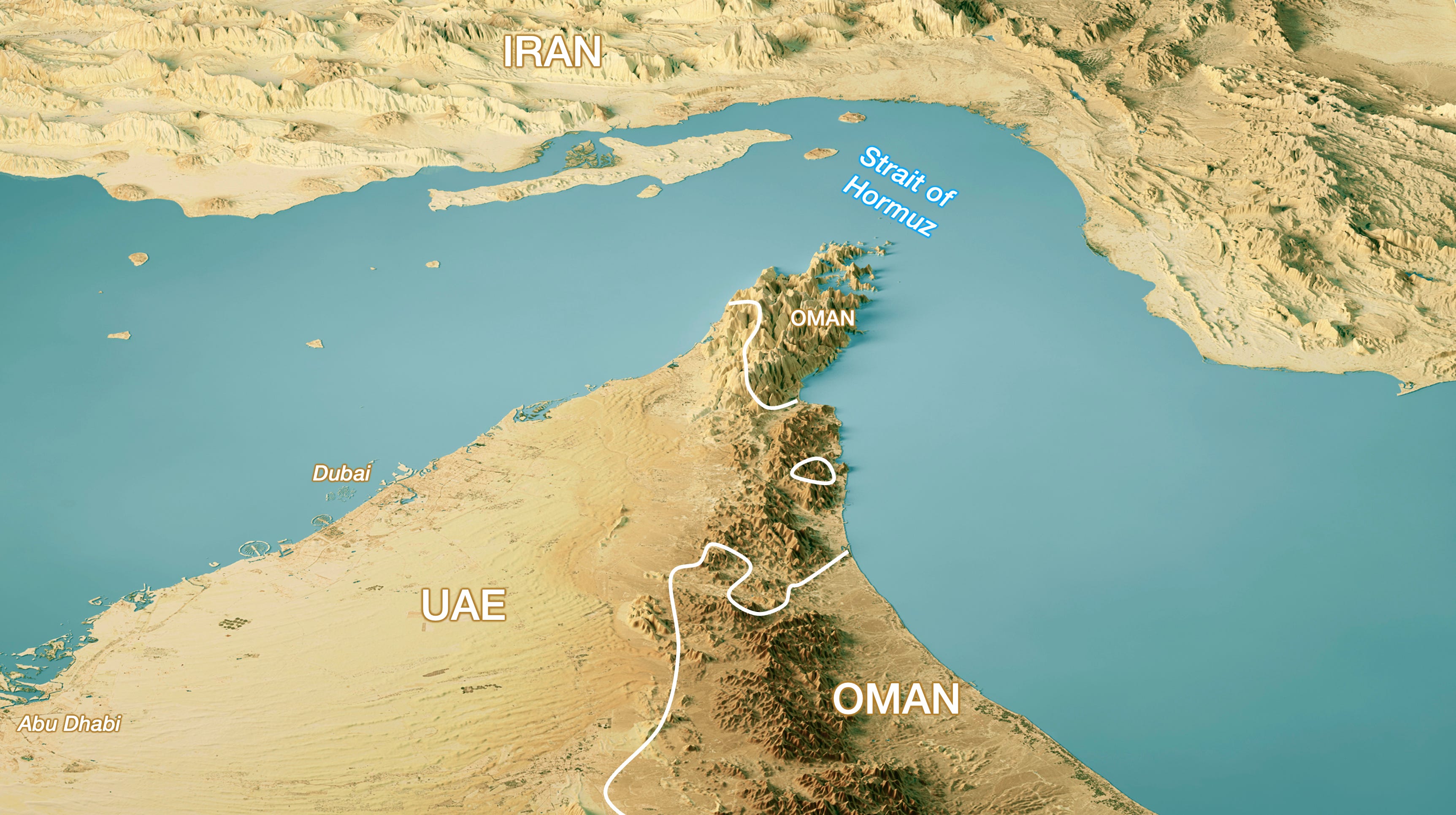
In the previous article, I omitted that Oman controls the end of the tip of the Strait of Hormuz on the western side. We’re working on an automated fact-checker to avoid these, if you find any mistake please point it out, it should help it get better over time.
One of the key hypotheses of Jared Diamond’s Guns, Germs, and Steel is that Europe had plains and mountains placed in such a way that they encouraged the formation of separate countries that competed against each other, and that this competition led to Europe’s progress.
Meanwhile, China’s heartland is the one massive North China plain, and from it, it’s reasonably easy to conquer adjacent spaces, none of which have plains that are as good.
This paper assessed this claim with numbers, finding that topography is sufficient to explain the formation of many countries in Europe and a single one in China. They found, however, that differences in land productivity could also explain this phenomenon. Specifically, the North China Plain is so hyperfertile—crossed by the two massive Yellow and Yangtze Rivers and crisscrossed by their tributaries—as to singly justify the centralization of China.
Until recently, I thought the world was mostly pristine until humans hunted many megafauna species (such as mammoths) to extinction a few tens of thousands of years ago and started cutting trees around 5,000–10,000 years ago to replace forests with farms.
But Against the Grain (no sponsorship link), argues that humans terraformed the Earth much earlier, among other ways through fire.
The main enemy was trees. They’re like very tall umbrellas capturing most of the sunlight from above and lots of nutrients from below, and producing wood and very high leaves, both of which are nearly impossible for humans and animals to eat—wood because we can’t digest it, and leaves because they’re too high.

Humans therefore burned them, which replaced trees with:
Ash, which is basically a concentration of all the nutrients that the trees have accumulated, placed onto the ground
No competition for sunlight
Fast growing bushes and grasses
The grasses could then feed animals, which could then be hunted
The bushes and grasses produced food that humans could eat, such as grains, seeds, nuts, shoots, tubers, and berries
Of course, the burning itself was a weapon, which humans used to hunt, for example by encircling animals, exposing nests and burrows, or pushing prey off a cliff or into traps or bogs.1
The best way to understand this as a system is as an improvement in the cost-benefit of calories. By transforming calories from wood and high-up leaves into edible plants and animals, fire increased the density of calories available to humans per acre, which also meant they had to walk less to feed themselves. A higher number of calories per acre is the single most important factor determining human population.
This fire thing has been going on for about 400,000 years, so the Earth we know (and even the Earth that the first farmers knew about 10k years ago), has nothing in common with the pristine Earth of 500,000 years ago. This includes the Amazon Rainforest, which has signs of this type of fire landscaping!
Food for thought for those who want to go back to a wilder Earth.
We can’t eat wood. But we also can’t eat most grasses. So it’s a big problem when most of the calories after a fire are converted into grasses. As I mentioned before, this was solved by animals eating the grasses. The mechanism here is that we used the bioreactors of animal stomachs, thanks to their gut bacteria, which transform grass matter into edible matter for humans.
The problem with wild animals is that you need to hunt them, which takes a lot of calories. So the ROI (return on investment) has a high benefit (meat!) but at a high cost (hunting!).
This was solved by domesticating animals. First sheep and goats, but also chickens, pigs, and cows, foraged for us, converted that organic food through their bioreactors into meat, and stored it right there without the need for salt or fridges, for us to harvest when we saw fit. We selectively bred these domesticates for the qualities we desire: rapid reproduction, toleration of confinement, docility, meat, and milk and wool production.
Fire is the other external stomach we’ve used. Cooking food makes more calories available to human digestion because it weakens the plants’ cellular protection, makes proteins easier to attack by enzymes, disables defensive chemicals, opens starch granules…
I never realized how harmful clans were to civil development.
Clans are families made up of several generations of siblings and cousins. They can be quite big, if they have lots of children and maintain connections with family members for generations. They’re a pretty natural way for humans to organize, if you think about it: You share your assets with your blood relatives, whom you likely trust more than the average stranger.
Unfortunately, clans have many disadvantages. For example:
By linking trust to blood, it makes cooperation between clans much harder.
Cooperation with complete strangers is even harder, because justice is served within clans. If you can’t keep somebody honest because you don’t know their clan, how are you supposed to trust them?
They prevent ambition, because the success of a single individual is shared across the entire clan. It’s like a huge tax, and taxes on labor reduce labor. Why would you work too hard if the fruits of your labor will be shared with others?
I’ve been reading The WEIRDest People (no sponsorship link), which advances the idea that the Catholic Church eliminating cousin marriage ended up weakening clans, so people had to start building institutions to coordinate with unrelated people, and that created institutions like guilds, chartered towns, religious orders, universities, companies, or stockmarkets.
This is supported by this paper, which provides evidence that:
The medieval Catholic Church's marriage regulations dissolved Europe's clan-based kin networks.
Strong kin networks are detrimental for democratic institutions.
So the Church contributed to the emergence of participatory institutions.
It does so by showing associations:
The weaker the ancestral kin, the stronger an ethnicity’s democratic tradition.
The more exposure to the Church, the more self-governed cities with participatory institutions grew.
The more cousin marriage bans, the more communes were formed.
The weaker kin networks, the more civic a group is, and the more political participation there is.
2026-07-17 14:05:46
I used to write quarterly updates on topics we’ve covered in the past. I haven’t done one for 6 months, so it’s time, but we’re going to try something a bit different. For a couple of weeks, I’m going to share much shorter articles every other day, covering specific areas we’ve discussed in the past. The next three will be GeoPolitics, GeoHistory, and Taxes. After that will come energy & the environment, robotaxis, AI in space, etc. Tell me what you think about the format! Every other article will be premium.
Also, there’s less than one week left to design the poster you’d love to see represent Uncharted Territories. The entries so far are all visible here. Here are the fan favorites, as of today:
It’s great to see some people interpreting individual articles or series too:
What do you think? Would you put one on your wall? Why?
Can you do better?
I added a creative brief for extra guidance. Don’t forget you can enter as many times as you like, so if you’ve submitted one and want to try again, go for it!
Entries close July 22.
$1,000 for the winning entry, announced on Aug 5, 2026.
I’m probably going to write a more complete article on this, but here are some salient facts from the last few months. Previous article on the topic here, here, and here.
The US still sells weapons—some of which through EU procurement—but that’s not enough to tilt the battleground, and SpaceX’s Starlink is private. Any involvement of Trump & Co in Ukraine is theater.
In 2025, Russia’s state budget was €470B, so the military represents 53% of the state’s budget!
This means Russia doesn’t have that much room to maneuver. Luckily for it, the Iran War increased oil prices, but they have now gone down.

Russia’s 2026 budget is expected to shrink, although amendments might change that. But that would not be good for Russia’s economic outlook.
A war of attrition is won by the amount of resources each side can employ, and how productive those resources are.
As a rule of thumb, Ukraine has a quarter of Russia’s population and is poorer per capita, so any ratio needs to be higher than 3:1 in favor of Ukraine for it to have a chance.
According to Ukrainian sources, the kill ratio of Russians to Ukrainians was ~5:1, and now it’s frequently 13:1 since Starlink stopped servicing Russian troops in February.
We can’t draw many conclusions from this, but one we can is that Starlink is becoming one of the most powerful geopolitical tools there is.
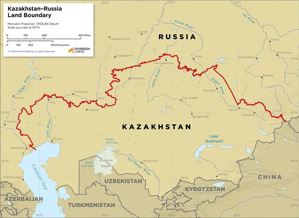
Kazakhstan just downgraded Russian in its constitution:
The new draft Kazakhstan constitution downgrades the status of the Russian language by specifying that Russian exists “alongside” Kazakh rather than sharing legal equality with it, a move upsetting Moscow and Kazakh nationalists for opposite reasons.
Kazakhstan used to be a key area for Russia to control to prevent attacks from horse-mounted hordes.
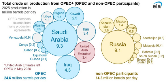
The UAE is OPEC’s 3rd largest producer of oil at 14% of the total, and it left the group on May 1st. That’s a pretty significant loss:
Why did the UAE do that?
Oil used to be the lion’s share of the UAE’s income. Not anymore, now it’s only about 50%. A bigger and bigger share of the UAE’s income comes from the returns on its sovereign wealth fund, or from the success of the non-oil global city of Dubai.
By leaving OPEC, it can maximize its own revenue by pumping out oil, even though it reduces the price of oil overall. In March, I wrote The Future of Petrostates After Oil, in which I claimed that petrostates would start pumping out more and more oil as peak oil demand approached and they realized that whatever they can’t sell now was going to remain unsold in the ground.
Saudi Arabia has fiscal issues: It needs to cover all the entitlements it promised its population and continue investing to prepare for the end of oil. So it’s in a much less flexible position than it was a few years ago, when it pumped out so much oil that prices fell to zero, forcing Russia to stop its oversupply of oil.
The UAE increasingly despises Iran (which is part of OPEC), as it’s been the country most targeted by Iran. And the rest of the Gulf countries have not come to the UAE’s defense. The UAE and Oman control one side of the Strait of Hormuz, and Iran the other. The UAE will do everything it can to avoid Iran gaining full control.
Iran is aligned with Russia. This is pushing the UAE towards Ukraine, whose counter-drone and anti-missile technologies are relevant to the UAE now.
And, crucially, the UAE is more and more at odds with Saudi Arabia, which came to a head in Yemen in January, 2026, with the UAE-backed side being ousted by the Saudi-Arabia one.
In the three articles about Argentina, I explained how its poverty was partially caused by its agricultural success, which brought lots of money when commodity prices were high, which then brought heavy export taxes to increase entitlement spending. This hindered agricultural production, and when commodity prices fell, the state’s budget broke.
We’re seeing one part of this cycle now, thanks to Milei’s policies. He’s been reducing export taxes on all commodities, and this is the result, for corn:
And for wheat:

The idea is not to stop all taxes. It’s that some taxes are good and some are bad. In general, you don’t want to tax the stuff that disappears when you tax it, just the stuff that remains. That’s why capital gains taxes are usually low in financially free countries (otherwise capital leaves), or why export taxes are bad: They make investment inefficient. Instead of taxing the exports, you want to tax the corporate benefits, which don’t penalize investment as much.1 That’s what Milei is doing: less export taxes, so that businesses invest more, grow more, and eventually pay even more taxes, via corporate taxes. We’re seeing the first half of that working, with record harvests—the result of investment.
I explained here what happened on the two occasions when Palestinians had historic opportunities to get their own state, and in both cases missed. As those close to these negotiations say, Palestinians never lose an opportunity to lose an opportunity.
This recent account from a Saudi Arabian minister at the time is interesting. He basically corroborates the US & Israeli versions and is aligned with what happened soon after: Clinton was replaced by Bush, the Israeli PM lost his election, and Palestinians lost their state.
In the video, he explains how Ehud Barak, the Israeli PM, said he had approved an agreement that his government and the Israeli public wouldn’t approve. He still signed. When the signature on the agreement was presented to the Palestinians, they used the situation to make more requests. Always more requests, mooting any agreement. And now it’s Arabs sharing the same type of details.
I'm opening the newsletter to sponsorship. If you have a business that is moving the world towards a techno-optimistic future and would like to reach 125k+ curious, globally-minded people to learn about it (founders, researchers, investors, policymakers), reach out here.
Imagine two exporters each sell $100 million worth of goods:
Firm A has costs of $60 million and earns $40 million
Firm B has costs of $98 million and earns $2 million
A 10% export tax charges each $10 million:
Firm A remains profitable.
Firm B goes from a $2 million profit to an $8 million loss and likely closes.
A profit tax automatically distinguishes high-rent operations from low-rent ones. A 25% profit tax would collect:
€10 million from Firm A
€0.5 million from Firm B
So the corporate tax earns more money and keeps more companies active.
Also, corporate profits don’t discriminate between local consumption and export. They also don’t penalize investments (since you can take them out of taxes via depreciation and amortization), but taxes on exports do.
2026-07-10 18:01:57
The contest for Uncharted Territories posters is ongoing. Go here to view the current entries and vote for your favorites so far. So far, my take is that there are many interesting concepts, in part thanks to AI, but that AI adds lots of meaningless details that don’t easily produce a great end product. The contest will remain open for a couple of weeks. Go here to submit your own entry!
I spent 15 years designing software products and businesses: reducing friction in onboarding, creating viral loops, building new features to increase retention, designing for improved network effects…
The more I did it, the more transparent the tactics that religions have used to grow became to me. It’s like the veil of complexity falls and the true structure of the world appears. Patterns that seemed incomprehensible suddenly make sense.
Yes, religion is like software: both produce ideas and rules instead of physical products, they have goals they translate into repeatable instructions focused on shaping human psychology and behavior, they have version control (anti-heresy) and forks (new sects), they optimize the onboarding, retention, viral loops, network effects…
With this lens, you start understanding why Christianity is the most widespread religion on Earth and why Islam spread so fast, having replaced smaller local religions like Facebook replaced Hi5 and SmallWorld. Why there are few Jews but the religion has survived 3,000 years, why each of these religions holds the beliefs it does, why their borders have barely changed in over 1,000 years, how they have evolved from one form to the other… You can understand why they emerged in the order they did, and why they were successful or failed. And it gives us a sense of what will happen with current religions in the future, and what new religions might arise.
And new versions come over time that improve on the previous ones, to make them work better and grow faster. In the previous articles, I showed how this is the case for Christianity and for Islam. The best way to illustrate this is through their evolution, from the v0 of animism and polytheism, following the software updates v1, v2, v3, v4, and v5.
Which hominid was most successful: Those who saw patterns and drew quick conclusions to explain their causes, or those who didn’t? Obviously, the ones that reasoned through causality: Those who heard rustling in the bushes and thought “Lion!” would live longer than hominids who heard rustling in the bushes and thought “eh, who knows.” The hominids who saw their brother get struck by lightning and thought “The gods don’t want us on that hill, especially during thunderstorms” would live longer than hominids who thought “I wonder if that happens every time.”
Hominids who were constantly seeing cause-and-effect patterns were probably wrong most of the time, but if you’re superstitious and avoid repeating any behavior that preceded something bad, then you’re going to pass your genes on, and a thousand generations down the road your descendants are going to have brains that are great at imagining patterns, even those that aren’t really there.
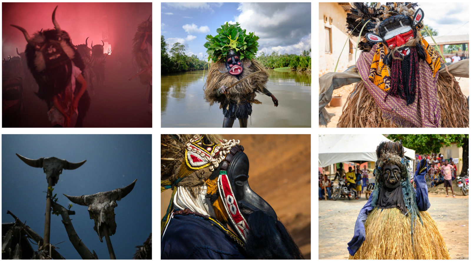
When too many humans gather and they don’t have rules to code their conduct, tension arises. This makes collaboration hard, which keeps them poor. The groups that were prone to ease these tensions through some sort of activity would be able to collaborate more, and prevail. We call these activities rites. From this article by Rob Henderson:
San Bushmen (modern hunter-gatherers) will occasionally engage in a dance to dispel what they call “star sickness.” This mysterious force encompasses jealousy, anger, interpersonal conflicts, and a failure to exchange gifts. Such pressures give rise to hostilities and damage cohesion in the group.
One of the most disturbing social elements is young males, especially those deprived of social, economic, and mating opportunities. Disputes between them can easily spiral into reciprocal violence, especially when large numbers of allies can be recruited. Rites tailored to them are especially important. Dunbar studied them in early societies, and found religious rituals, feasting, singing, and dancing that have been shown to enhance social cohesion. Other social innovations (e.g., men’s clubs, socially recognized leaders) and regulated relationship arrangements (marriage, kinship, dowries) are all geared to lowering young male violence.
Ceremony is an important part of these social rites. From the book Ritual: How Seemingly Senseless Acts Make Life Worth Living, as explained by Henderson:
In a video, a man performed the ordinary action of picking up a glass, cleaning it with a cloth, pouring the drink, and inspecting it before setting it on a table.
In another video, the event was ritualized: after picking up the glass, he waved the cloth at it without touching it, raised the container high up before pouring it into the glass, and bowed to the glass before setting it on the table.
When the researchers asked participants whether the two glasses were the same in terms of their physical qualities, the participants generally said yes. But when asked which one was more special, a significant difference emerged: they favored the ritual drink. When asked which beverage they would prefer to have, participants were three times more likely to pick the “special” drink. And when participants were told that the gestures were part of a traditional ceremony practiced in Fiji, Gabon, or Ecuador, participants were even more likely to select the ritual drink.
So it looks like we’re naturally geared towards religious belief. What did it translate into?
When your daily experience is of nature, plants, animals that hide in bushes or under cover of darkness, their skeletal remains after death and consumption… The natural thing is to assume they share a similar experience to yours: Spirits inhabit every animal, like they inhabit every person. This is why most early societies were animist.
And since your daily experience is that of humans and animals, you bestow upon them the abilities of humans and animals, just more powerful. Gods eat, sleep, lust, lie, and get fooled like humans do. They feel love, sadness, anger. They’re also pretty amoral and selfish: They don’t care much about what happens in the big picture, just about what happens to them and their supporters.
Then came agriculture and suddenly humans start controlling their environment. A clear hierarchy starts emerging: humans above plants and animals. It makes sense that now not all animals and things are spirits, and humans emerge as having a special relationship with gods.
Gods become more and more human-like.
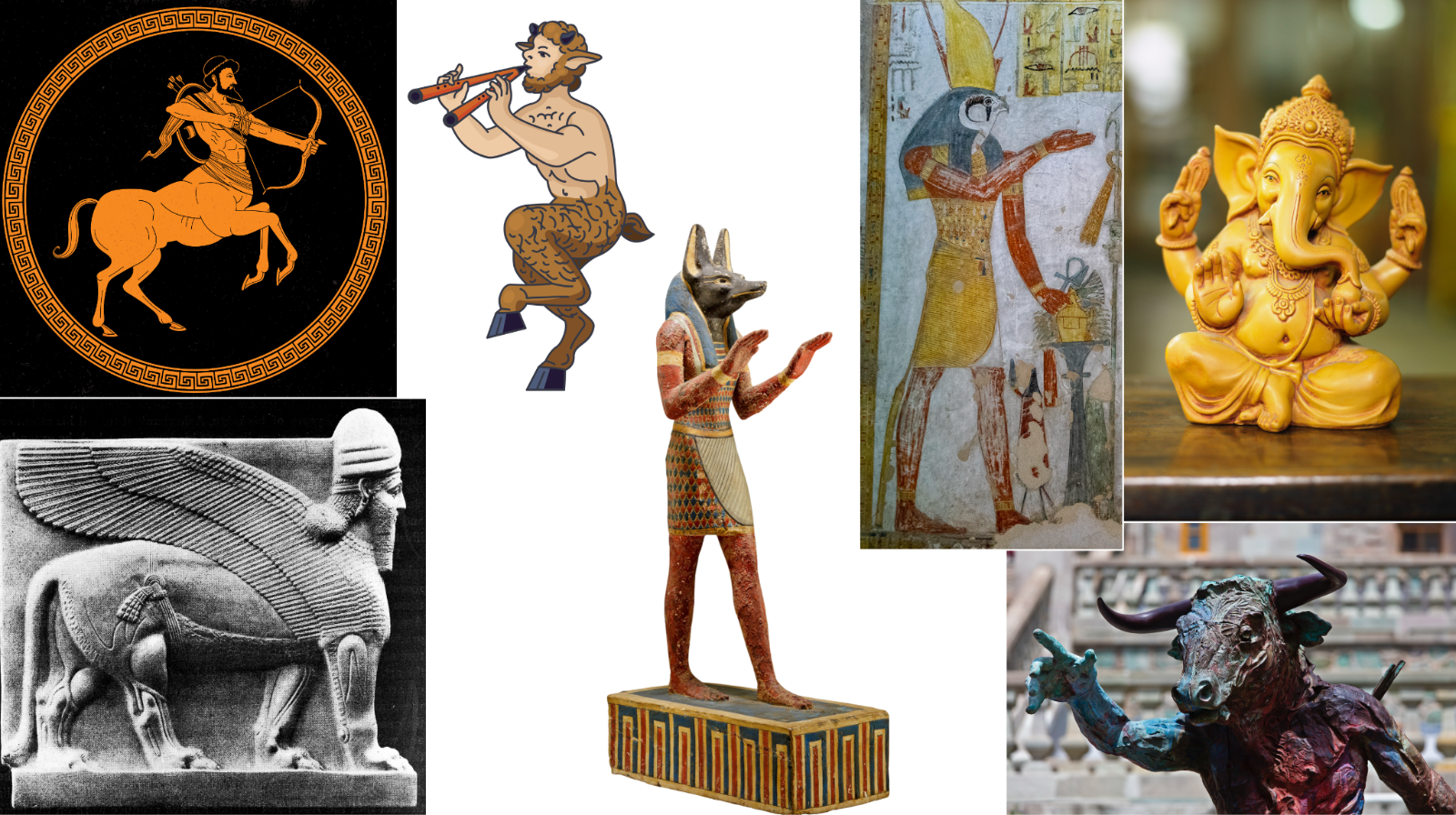
As agriculture becomes more widespread, life and death don’t depend on the animals and plants around you, but rather on weather, pests and wars. So it makes sense that each of these big factors of survival develop their own gods.1
Humans think gods trade favors with them: If you give them the right gift or the right sacrifice, they will be happy with you and will help you with whatever power they have. The relationship with them is like with a patron: You sacrifice something when you need something—rain, victory, a child. If you anger them, they’ll side against you.
Rituals are attempts to get these fabulously powerful but mysterious entities on your side, and they’re designed through trial and error: You gave a part of your harvest to the farming goddess, and the next year the harvest was great? Surely, that made her happy. We must continue. But we don’t know exactly what part of the rite worked, so we should try to copy it very precisely to make sure it works again. The clan that knows a specific rite controls a god and gets social advantages. The more rites and gods you control, the more power your clan has.
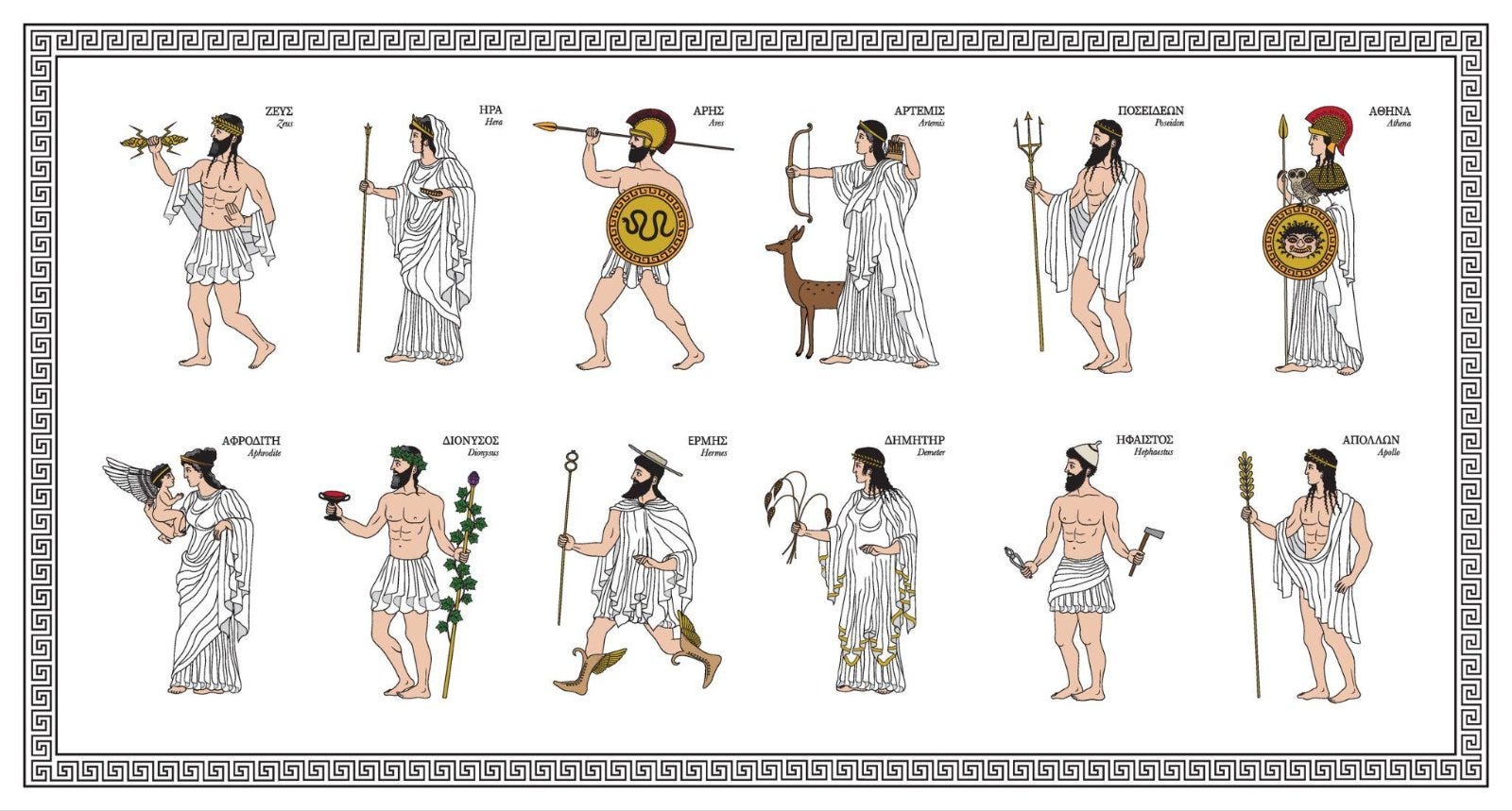
You prayed to your god before a battle, but you lost? Surely, your god is weak, and the god of the conqueror is stronger, so you might as well pray to him instead. That means they have specialties and territory over which they have jurisdiction, just like humans and animals. This means gods are local to specific regions. They can only perceive what they see or hear, which is why in the Iliad Hera seduces Zeus so that he doesn’t watch the battlefield, or why Diomedes wounds Aphrodite with a spear.2 There can be many gods, no exclusivity. There’s no ritual to convert or to be a member, no commitment, because there’s not really a full concept of a cohesive religion, just a bunch of gods that exist.
The further a society removed itself from nature, the more human its gods became.
Notice how these features make these religions weak:
Since gods are local—with their homes in specific cities or regions—they can’t spread much.
That ties them to the local state. When the state crumbles, the religion goes with it: Surely, the god must not have been very powerful if his protected state failed.
Everybody has a different version of the gods, and few of their features get recorded, because nobody knows them definitively: Everyone is just trying to figure out what they want through trial and error. So they evolve across time and space, they merge with other deities, they lapse…
If you like The Avengers, you understand these gods’ appeal.

Within these belief systems, some features of future religions start peeking through.
In Ancient Egypt, there’s an afterlife. People’s hearts are weighed at death, the wicked are annihilated, and the good survive. If you think about it, that’s pretty natural: Evolution has given us a fear of death, so coming up with an afterlife is the most reassuring belief. Tying it to proper behavior is pretty intuitive too, as that’s what happens in human interactions: Be nice to people, and they reward you. In the case of Egypt, good meant avoiding violence, exploiting the weak, theft, cheating, cruelty, lying, sacrilege, and public disruption. We can see an ethnic system emerge.
But this proto-feature is only accessible to elites, is only summarily defined,3 and isn’t tied to spreading the religion.
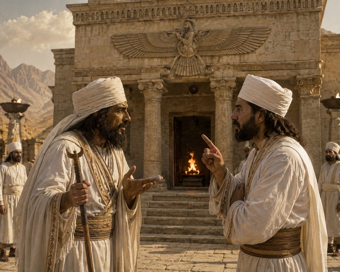
Zoroaster came to change this.
The religion of Ancient Iran started moving towards monotheism between 2000 and 1000 years BC. Then, between ~1200 and 600 BC appears Zoroastrianism, spurred by the religious reformer Zoroaster4. Zoroastrianism displays some interesting religious innovations.5 The most important is the crystallization of good and evil for everybody. There is still a judgment after death, but now it applies to everybody, not just the elites or those who could afford it. People do good things because they’re good, and vice versa. You should do more good things to be good, and fewer bad things. When you die, your specific soul is judged.6 This enables moral enforcement for every individual among the population. This judgment gets linked to an afterlife, and a proto-heaven and hell appear, which is very convenient because they’re a super cheap way to enforce behavior.
PRIEST ZOROASTER: Something very very very bad will happen to people if they don’t behave properly!
PRIEST DARIUS, whispering to ZOROASTER: But how can we know somebody did something wrong? How do we identify them? Punish them?
ZOROASTER: We go get them.DARIUS: With what power?
ZOROASTER: Soldiers!
DARIUS: What if the soldiers don’t want to do it? Or are too expensive? Or at war? Or are the perpetrators? Or there are too many bad people? Or we can’t witness the deeds?
ZOROASTER: Good points. Hmmm…. OK OK, hear me out: What if we say the judge is God, not us, and he sees much more than us?DARIUS: Okay, but how will people know we’re telling the truth? They’ll do a bad deed, wait for retribution, it won’t come, so they’ll carry on.
ZOROASTER: OK hold on… What if it happens after death?
DARIUS: What do you mean?
ZOROASTER: That way, they can’t say it’s false. They have no proof! They’ll be punished after death!
DARIUS: Genius! But we need to make sure the stick and the carrot are huge, otherwise people won’t care.
ZOROASTER: What if the punishment is really bad and it’s like forever? And vice versa: If you’re cool, you get a cool afterlife forever?
DARIUS: Yeah, totally, that would do it!
By introducing the concept of being good to each other, we suddenly get a religion that can enforce moral, collaborative, positive behavior across an entire region. People work more together instead of killing each other, wealth can accumulate, and society thrives.
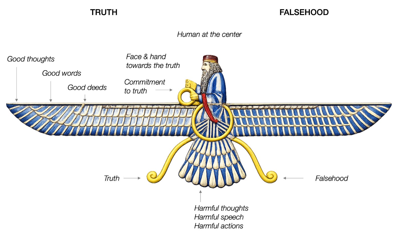
Another innovation is that religion becomes dualistic: Only two main gods, for Good and Evil. All other deities become secondary. That’s just one step removed from monotheism: Obviously, everybody should follow the good one.
These innovations were certainly not designed with intention as I described in the conversation above, they likely came about through evolution. But as we know from the debate between intelligent design vs evolution, you don’t really need intelligent design for something significant to appear. With enough time, evolution can make it happen. The mechanism would be something like:
Lots of different prophets and priests are always coming up with new software ideas.
They debate ideas and combine them.7
The cleverest, most charismatic, or luckiest ones come up with a (software) combination that is more productive than any other version. This one spreads.
Entrepreneurial and efficient priests (which might or might not be the same as the theoreticians) take these ideas and help them spread faster and farther.8
In any case, Zoroastrianism was so successful that it became the state religion of the Persian Empires until the 600s AD, when Arabs conquered the Sassanid Empire and introduced Islam. Zoroastrianism persisted for centuries, but eventually dwindled. Yet today, there are still over 100,000 Zoroastrians in Iran. That’s the power of installing valuable new software.
But why did it appear then and there? Karl Jaspers and Peter Turchin speculated that they were the result of technological development. Here’s my interpretation.
Several innovations happened between 4000 BC and 1000 BC, including the domestication of horses, their mutation to be able to carry humans on their back, the invention of the wheel, and the discovery of iron smelting. These inventions made farming much easier and scalable. And war. Horseback riding enabled horse-mounted roaming. Curiously, as soon as the secret of iron smelting became widespread, most eastern Mediterranean civilizations collapsed, probably enabled by bandits who now had easy access to weapons.
All of this suggests that, through these thousands of years:
Empires became viable, because agriculture improved and now farmers could generate calorie surpluses, while technologies of violence allowed these farmers to conquer others.
At the same time, roaming bandits became viable too. The unconquered people would rather raid the farmers with their horses and iron weapons than do the farming themselves.
The bigger the empires, the harder to maintain their cohesion, and they would fall apart.
Prophets would witness these problems and propose solutions that had to be moral because the problem was of social coordination.
As nomad military superiority forced agrarian states to scale up to resist pressure from the steppes, one cultural mechanism for holding together ethnically diverse people in new mega-empires was the presence of unifying, ‘meta-ethnic’ (supranational) ideologies, such as Zoroastrianism in the Achaemenid empire, Buddhism in the Maurya empire, and Confucianism in the Han empire. Turco-Mongolian nomads (perhaps going as far back as the Xiongnu) had their own integrative meta-ethnic religion, Tengrism, although it is not usually viewed as a world religion.—Peter Turchin
Alas, although Zoroastrianism is productive software, that doesn’t make it everlasting: It doesn’t really focus on acquiring believers or retaining them. The next iteration would improve one of these aspects.
2026-07-09 07:53:28
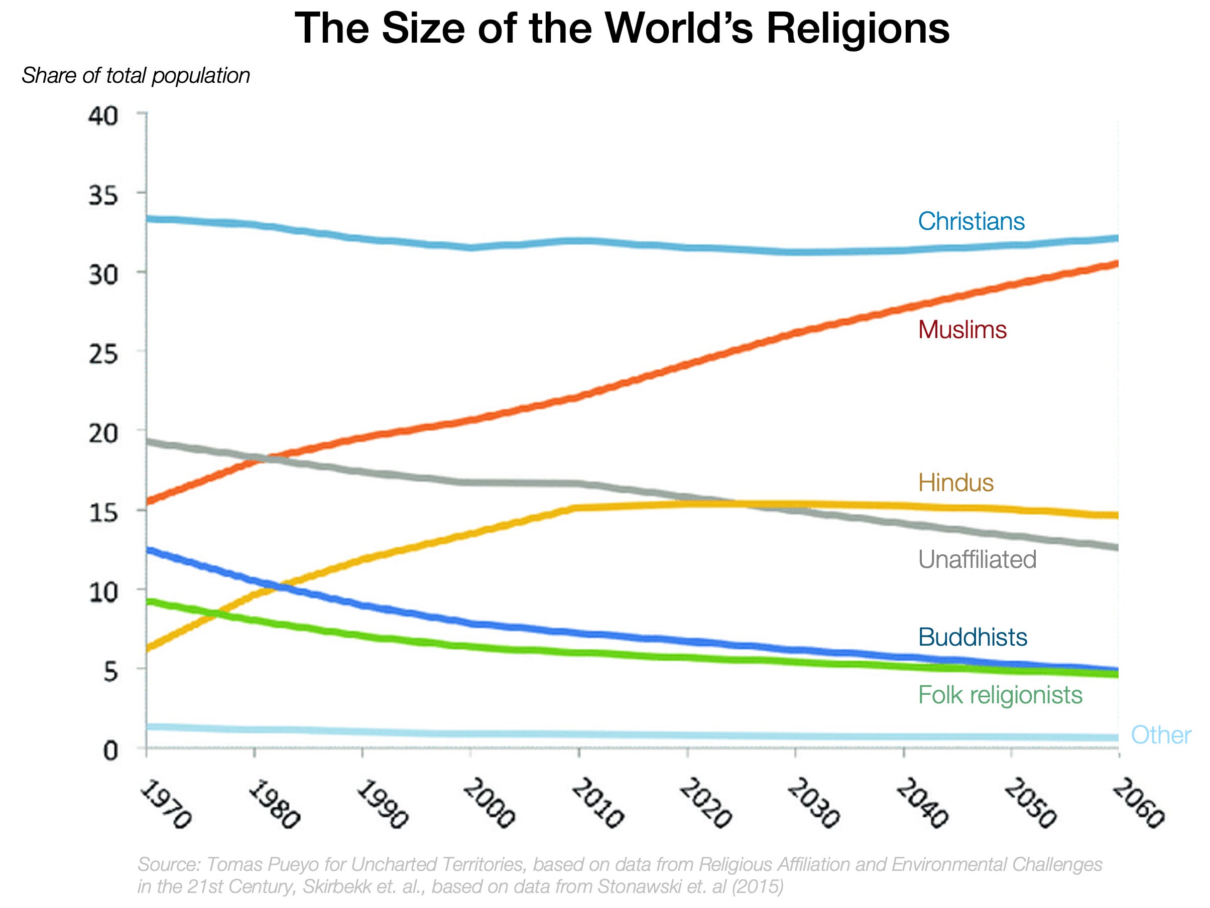
If things continue the way they have, Islam will overtake Christianity in the next few decades.
Why?
In How Did Islam Spread so Fast, I explained the origins of Islam, and some of the ways it spread so fast. Today, I’m going to do what we did with Christianity: Go deeper into Islam’s software growth strategies and how it distinguished itself from Christianity and Judaism to accelerate its virality. This will help us guess whether this will continue, and at what cost.
I don’t speak Arabic, so I can’t confirm this claim, but apparently the literature of the Quran is so exquisite that it became a sales argument to convert people into Islam: Surely, an illiterate like Muhammad couldn’t have created such beautiful prose by himself; it must have come from God!1
Christianity’s growth took place in the Roman Empire, because it benefited from the peace and trade of the Pax Romana. Peace was a given. Muhammad was not in that world. Arabia suffered tremendously from clan-on-clan aggression. The only way to end that tribal warfare was to create an ethnic unity above the clan: the Ummah. You can’t attack fellow Muslims, so this measure ended all the blood spilled in clan warfare, and replaced it with inter-clan solidarity.2 This was a great source of user acquisition (We need to grow the Ummah!) and retention (You must remain in the Ummah!).
Christianity was the first to make social security a core pillar of growth. But how much should members pay? Can they refuse?
Islam solves this with the Zakat: It’s called charity, but it’s closer to a tax. You’re expected to pay ~2.5% of your wealth every year if you can afford it.
Jesus started preaching to Jews. His apostles broadened the TAM (Target Addressable Market) to the whole of mankind, the first time that had ever happened. The Great Commission tells everybody to go and convert others—quite a viral improvement!
Muhammad’s brilliance was to make that virality aggressive. Islam takes the peaceful proselytism of Christianity, and adds the aggressive growth through the sword. Since Arabs were already accustomed to raiding because of their clan warfare lifestyle (due to the geography of the area), it was just an outward expansion of their existing lifestyle.
Also, the sales team got compelling compensation incentives: a sizable share of revenue generated (i.e., spoils of war).
To motivate your sales team, you want to give them a share of the business they generate. In Islam, that’s Ghanimah, and includes 80% of war spoils, plus captives. Not bad!
Your sales team might be a bit too cautious, though, and not go the extra mile. So you want to incentivize them to take risks. The problem is that, in war, taking risks often means death. So, brilliantly, Islam invented the superbonus of heaven with 72 virgins.
It’s usually a bad idea to force your customer base to convert to your religion. They tend to revolt. So instead, Islam allowed non-believers (the Dhimmi) to keep their religion, but they had to pay higher taxes (Jizya) and had fewer benefits and less access to power. Over long periods of time, this resulted in their conversion to Islam.
To convert to Judaism, you have to study for years, and if you’re male, you must cut your penis. To convert to Christianity, you also have to study for years, and to get baptised, you need a profession of faith, repentance of sins, and instruction in church teachings.
In Islam, you just say out loud: "I bear witness that there is no god but God, and I bear witness that Muhammad is the Messenger of God."
Lowest friction onboarding process ever.
You don’t only grow by converting new customers, but also by having your customers reproduce more.
We saw how Christianity did this, basically banning all non-vaginal sex, and only allowing it to happen within marriage. But Christianity has a feature that impedes its reproduction rate: With its idea that God loves all the creatures it created, Christianity embedded the future development that women are equal to men.
Muhammad does not say that. For him, men are in charge of women and can even strike them if they disobey. This, in practice, means that men have more access to sex within their marriage, and that the woman is in a weaker position to oppose sex and having more children. In general, more egalitarian societies have fewer children.
Ironically, when Muhammad said men could have four wives, it was meant to be progressive: They could only have four wives.
Did that increase reproduction? I think it depends on which system focuses most male effort on their progeny.
In monogamy, most men have a wife, so most of the resources of each man are dedicated to rearing children, but this is especially true for poor men. Rich men, with only one wife and her children, might have many more resources they’re not dedicating to their children.
In polygyny, many poorer men don’t have a wife (and hence children), so their work is not dedicated to child-rearing. However, a greater share of powerful men’s resources are dedicated to child-rearing, as they have more children with more women. I’m not sure which one of these two models wins.
However, in polygyny, the stock of poor men without access to women means they’ll be frustrated, and they became a tool for violent expansion of Islam through Jihad.
On balance, I don’t know whether polygyny increased the number of children in Islam, but it certainly increased the “inorganic” growth of Islam—via conquests.
Muslim men can marry non-Muslim women,3 but the opposite is forbidden. This makes sense, as the limiting factor for reproduction is female fertility. As a result, Muslim women remain locked into Islam, while Muslim men (less scarce) can go out and take the risk of conversion (both out of Islam for them and into Islam for their wives).
Whereas in Judaism the children of Jewish women are Jewish, Islam asked: Why not make the children of Muslim men Muslim, too?
No need for baptism, even. It’s automatic.
If Islam’s user acquisition has been aggressive, its retention has nothing to envy. Taken together, it’s clear why Islam is overtaking Christianity: